Trail Difficulty – Intermediate
Trail Length – 23.4 miles
Trail Time Share – No
Ride Type: Loop / Out & Back / Shuttle
Ascent – 4614 ft.
Descent – 4497 ft.
Min Elevation – 5682 ft.
Max Elevation – 7925 ft.
High Resolution Topo Maps
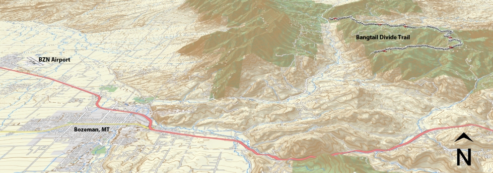
 This is one of Bozeman’s premier mountain bike trails as well as an IMBA epic! The Bangtail divide trail gives you incredible views of numerous surrounding mountain ranges as you traverse along the ridge line. The accessibility to bangtail divide trail is a short distance from downtown Bozeman. Most riders prefer to ride the trail from the south end (Stone Creek) and finish at the north end (Brackett Creek). The trail begins with a solid climb right out of the parking lot of Stone Creek trailhead with approximately 20 tight switchbacks cut into a steep hill. As you continue up stone creek the climb mellows out slightly; and you can begin to see that you are
 leaving the comforts of valley below and entering the beginning of an epic ride. As you reach the summit of Stone Creek you will exit the steep hillside and find yourself in a high mountain meadow, with an old barb wire fence that you will eventually follow for a few hundred yards. Now is a great time to stop and take a few pictures of Bozeman in the distance and eat some food to continue to fuel your ride. At this point you have completed the majority of the continuous climbing portion of the ride. The trail starts to have a cross country feel to it with a flowing single track through new growth trees. You will be meet by more uphill climbs that weave in and out of dense forests and open meadows, which are filled with wild flowers begging for photo opportunities. At about the halfway point you will enter a relatively large meadow that seems to stretch into the
distance (nicknamed Stoney Meadow). After leaving the openness of the meadow you plunge into a dense forest of fast flowy single track kindly named the enchanted forest (or ninja woods). The trail continues north and crosses Olsen Creek access road. This is the beginning of the last climb before you reach the summit of Grassy Mountain. For all your hard work, up to this point you are greeted with a super fun 4 mile downhill into Brackett Creek trailhead. At this point you can either ride the Bridger Canyon road back to your vehicle or you will have needed to plant a vehicle at the Brackett Creek parking lot.
Driving Directions:
From Main Street in the center of Bozeman take Rouse St. north following signs toward Bridger Bowl Ski Area. Rouse turns into Bridger Canyon Road (Highway 86). Continue north for approximately 11 miles. Turn right on Stone Creek Road (a dirt road). Follow that road to large parking area where road is gated. It is not uncommon to see cars parked near the highway. These are usually fellow riders that have beaten you to the ride. The trail takes off on the south side of the road just before gate. The Bracket Creek trailhead is another 8 miles north of Stone Creek just east of the Highway 86/Brackett Creek intersection.
Google Maps Driving Directions (IOS and Android compatible)
Stone Creek Trailhead
Brackett Creek Trailhead


