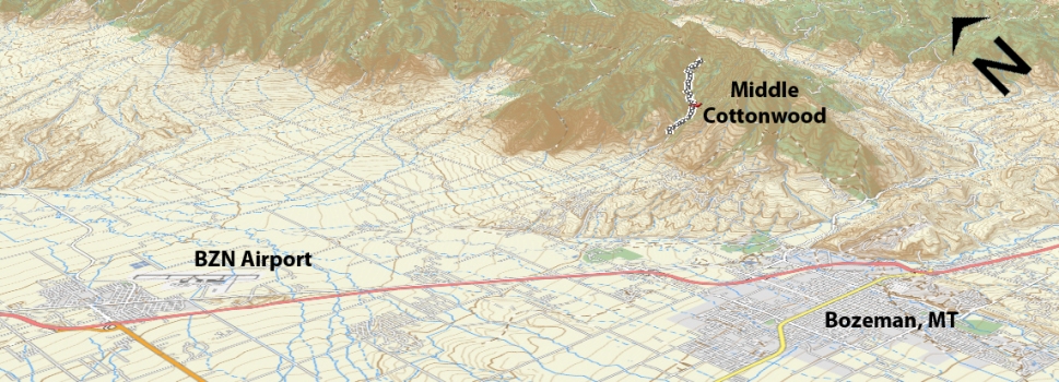
Ascent – 2012 ft.
Descent – 2037 ft.
Min Elevation – 5467 ft.
Max Elevation – 7337 ft.
High Resolution Topo Maps
Possibly one of, if not the most technical trail in the area. Beginning with a mellow trail that is wide and heavily traveled by hikers (so watch your speed at the bottom on the downhill). Once past the lower well-traveled area the trail becomes very technical in areas, and still maintains a high level of technical skill to ride the areas in between. Middle Cottonwood boosts some very unique terrain features as you climb out of the lower forest and into high mountain meadows. Once you pass through the meadows the trail skirts around a ridgeline with a fairly exposed edge off to your right (no fall zone) which begins another section of unrelenting technical uphill. Most riders stop around the 3 mile mark. If you are feeling strong or just willing to push your bike another 1 ½ miles, you can climb all the way to where the trail branches left along the Bridger Foothills trail (heading North) or straight up towards Saddle Peak. This trail is best ridden by a rider with solid bike handling skills and at least a 5” travel full suspension.
Time Share Trail – More information on timeshare click here.
The trail is open to mountain bikers with timeshare restrictions from June 16th – September 4.
Driving Directions:
From Bozeman, head North on 7th Avenue. Continue over the highway overpass, drive 2 miles north on the Frontage Road to the light at Springhill Road. Turn right on to Springhill road and continue 3.4 miles to Toohey Road. There is a sign for Middle Cottonwood Creek. Turn right on Toohey Road and drive 1.7 miles to Walker Road. Turn right on Walker Road. Walker Road turns left at about ¼ mile and becomes Saddle Mountain Road. Stay on this road for about 3.2 miles to the Middle Cottonwood Trailhead. The trailhead can also be reached via Sypes Canyon Rd. Once on Sypes Canyon Rd turn left on Sumner Cutoff Road and drive till the road T junctions. Turn right on Saddle Mountain Road and continue on this road after it turns to dirt all the way to the trailhead.
Google Maps Driving Directions (IOS and Android compatible)
Middle Cottonwood Trailhead


